The Columbia River Gorge Waterfalls and Dams

The Columbia River is a wide, deep gorge to the east of Portland, Oregon. Many waterfalls are present near the south river bank. We drove from Portland east on I-84 to exit 18, the Historic Columbia River Highway. This road becomes the East Crown Point Highway just before the first of the falls, Bridal Veil.

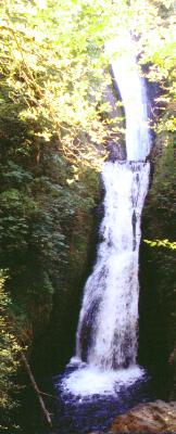
There are falls not shown on the computer maps we use to plan our trips. Signs along the road tell of the falls. Most of the falls are in state parks. Bridal Veil Falls does show on our maps. The falls is reached by walking a short trail down from a paved parking area beside the road. Once at the falls viewing area, trees partially block a view of the upper falls. There are places where the upper part of the falls can be seen, but then the lower part is blocked. I discovered that the falls actually starts at a bridge for the road we were traveling.

Wahkeena Falls did not show on my map, but was easily found by simply following the signs.

Multnomah Falls is reported to be the second tallest waterfall in the USA that has water year round. At 628 feet, it is not as tall as several other falls, but it never freezes completely, and it always flows. According to a park ranger, a taller falls is near Mount Ranier Park, but you cannot drive near it. Multnomah Falls is very near I-84. In fact, there is a parking area in the middle of I-84 for the falls, and an underground walkway to the falls.

Views from the bridge. There is a lodge, a gift shop, and rest rooms at Multnomah.
A little farther east from Multnomah is Horsetail Falls, pictured here. It is right by the road, with the parking area across the road.

A great web site that describes all the waterfalls in North America is http://home.earthlink.net/~geoffcon/gallery.htm,  with http://www.waterfallsnorthwest.com/cgo.htm leading to all those in the Columbia River Basin. As can be found at that site, there are many, many more falls in the gorge than we saw. We only saw the ones that are easily reached from the road.

I guess that all waterfalls are pretty, but none of these are close to the magnificence of  Takakkaw Falls that we saw earlier in Canada's YOHO National Park.

We visited these falls, after obtaining a motel room in Troutdale, the same day (8 Sept) that we visited Mount St. Helens. All of these waterfall pictures were made with a 28-80 mm camera lens because our normal 28-200 mm lens stopped working. The next morning we drove to Camera World in Portland and purchased a new 28-200 lens. The convenience of the wide range zoom is very important to us.

We visited Bonneville Dam and Fish Hatchery on 9 September. There is a self guided tour of the dam that includes a model and historical aspects of the dam. A movie is included. The dam has a fish ladder with parts of it viewed from inside the dam. The fish ladder is also viewed from outside. I found the hatchery more interesting than the dam.

Several types of fish can be seen at the fish hatchery. I was most impressed by Herman, the 12 foot sturgeon. Several other sturgeon are in the ponds.


The fish hatchery is located on the south shore below Bonneville Dam so that spawning fish do not have to pass by the dam. Chinook and Coho salmon are raised at the hatchery. Both types were on their spawning runs while we were there. The returning salmon were trying very hard to return to the ponds where they were raised. Two can be seen here trying to jump over the gate that is raised when the young salmon are released to swim downstream. These fish are almost two feet in length.

There are more dams on the lower Columbia River, but this is largely a case of seeing one is enough for one trip. There is more to see in the gorge area, though.

Continue to More of Oregon

Return to Mount St. Helens.

Return to Our Scenic Tour of 2001.

Return to Lewie's Home Page.