Our Trip of 2003
Utah Canyons to Home
We spent several days in southern Utah. This entire area is loaded with beautiful, red rocky formations. The several national parks and monuments have concentrations of the formations, and have the necessary roads, public trails, and platforms that allow easy viewing at close range.
Note: Additions will be made to include multiple pictures of several stops. Click on a picture for more
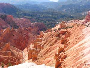
| Cedar Breaks NM was the first stop. It has
aptly been described as a miniature version of Bryce Canyon NP. |
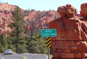
As we headed for Bryce Canyon, we drove
through Red Canyon, a region that looks a lot like Bryce Canyon. A few
pull-offs are provided along the highway. |
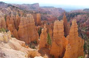 Bryce
Canyon Hoodoos, Fairyland Canyon. Bryce
Canyon Hoodoos, Fairyland Canyon. |
Bryce Canyon NP has a number of side canyons that lead into the larger canyon. All have the tall, rocky structures known as hoodoos. The roads in the park lead to several viewing platforms with names such as "Sunrise Point" or "Inspiration point". Each view is different from all the others, and all should be visited. Most of the side canyons open toward the east. A sunny day gives strong shadows for pictures. A gamma increase with Photoshop shows detail in the shadows . |
All the views in Bryce Canyon are from
the canyon rim. In Capitol Reef NP, the road is in the bottom of the
canyon giving a different perspective. Only a few hoodoos, but lots of
beautiful multi-colored rock formations.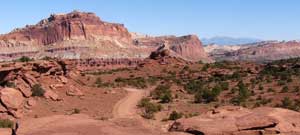 |
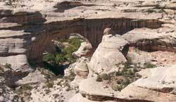 Natural Bridges NM has three natural rock bridges that are easily seen
with downward views from roadside viewing areas. Closer, upward views can
be had from trails to the river basin
Natural Bridges NM has three natural rock bridges that are easily seen
with downward views from roadside viewing areas. Closer, upward views can
be had from trails to the river basin |
We next drove into Colorado, New Mexico, and
Arizona, and briefly returned to Utah. All at the same time at the Navaho
operated Four Corners monument.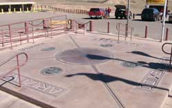 |
Next stop was Page, AZ, home of Glen Canyon
Dam and Lake Powell. The dam visitor center is to the left of the dam,
with access from Page over a high bridge in front of the dam. 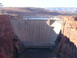 |
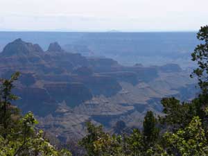 |
The north rim of the Grand Canyon was the next stop. Smoke or haze severely limited the viewing range. From the north rim, most views are into side canyons instead of into the main canyon. I prefer the south rim views that we had a few years ago. |
 Next was the Hubbell Trading Post at Ganado, AZ. The most
interesting part of this stop was to see the prices of Indian woven
baskets. I had no idea they were so expensive.
Next was the Hubbell Trading Post at Ganado, AZ. The most
interesting part of this stop was to see the prices of Indian woven
baskets. I had no idea they were so expensive. |
We visited the Goldfield Ghost Town
near Phoenix, AZ, and rode their tour train. Interesting tourist place. 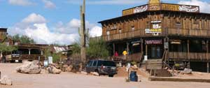 |
We next visited the Organ Pipe Cactus NM in
southern AZ. Lots of different types of cactus with labels so you know
what you are seeing. 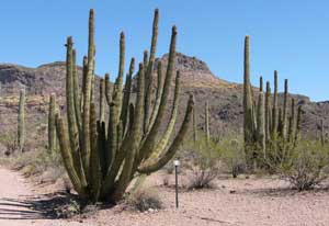 |
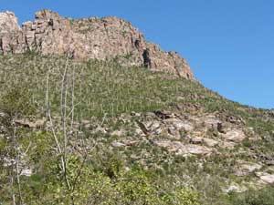 We
also visited Sabino Canyon near Tucson, AZ. A train-type tour along
the road through the canyon was taken. Cars are not allowed. Interesting
sights. We
also visited Sabino Canyon near Tucson, AZ. A train-type tour along
the road through the canyon was taken. Cars are not allowed. Interesting
sights. |
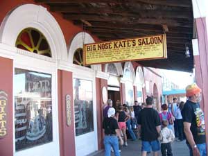 Next
stop was Tombstone, AZ, home of the Gunfight at the OK Corral. Also home
to many historic places from the time of Wyatt Earp, including Boothill
Cemetery. Next
stop was Tombstone, AZ, home of the Gunfight at the OK Corral. Also home
to many historic places from the time of Wyatt Earp, including Boothill
Cemetery. |
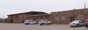
Next was a tour of the Queen Mine in Bisbee,
AZ. It is cold and damp in the old copper mine. They supply the hard hat
and rain coat. Tours are conducted by retired miners. Only a few mines are
still active in the area. A large open pit mine is nearby. 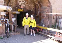 |
We next returned to our home state of Texas
and visited the Hueco Tanks State Historic Site. Indian pictographs are in
small caves or overhangs. Graffiti from stage coach era people is also
there, along with more recent vandals. 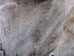 |
Next was the Guadalupe Mountains NP. We did
not see much of interest there since there was not time for a hike deep
into McKittrick Canyon. The descriptions at http://www.nps.gov/gumo/gumo/mck.html
makes me want to return.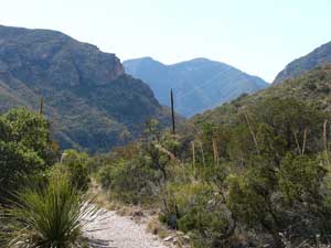 |
A stop was made at Fort Lancaster Historical
Site. This was a spur of the moment side trip instigated by a sign on
Interstate 10. Ruins of a pre-civil war fort abandoned in 1861.
While unplanned, it provided a scenic drive through desert country and a
bit of history that was interesting. Much better than the Interstate.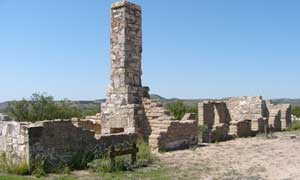 |
Our last stop before home was at the Caverns
of Sonora. The first part of the cave is boring, with not even a stalactite
to see. The cave then becomes the most beautiful that I have seen, with
massive cave coral formations and delicate formations such as a butterfly
and fish tails. 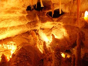 |
Go to page 1, Earl Park to Mackinac Island.
Go to page 2, Ontario to Treeline.
Go to page 3, Yellowknife to Las Vegas.
Go to Lewie's Travel Web.